Petrophysics
Moosetooth personnel has extensive and practical experience in a multitude of basins and depositional environments. We can apply our experience to help you make the right decision and further prosper your business.
Overview
The well log dataset within the United States is tremendous and its usefulness cannot be overstated. Any successful oil and gas company must leverage this data by applying petrophysical techniques to characterize the reservoir and better understand lithology, porosity, and fluid composition.
Application of advanced petrophysical methods allows an operator to predict hydrocarbon production based on quantitative means rather than a gut feel. Calculated results are important to guide the operator to make correct decisions for drilling new locations, pursuing an interval of interest, or walking away from an endeavor that proves too risky. Making the correct decision in any scenario is vitally important to the economic success of an operator.
Moosetooth personnel has extensive and practical experience in a multitude of basins and depositional environments. We can apply our experience to help you make the right decision and further prosper your business.
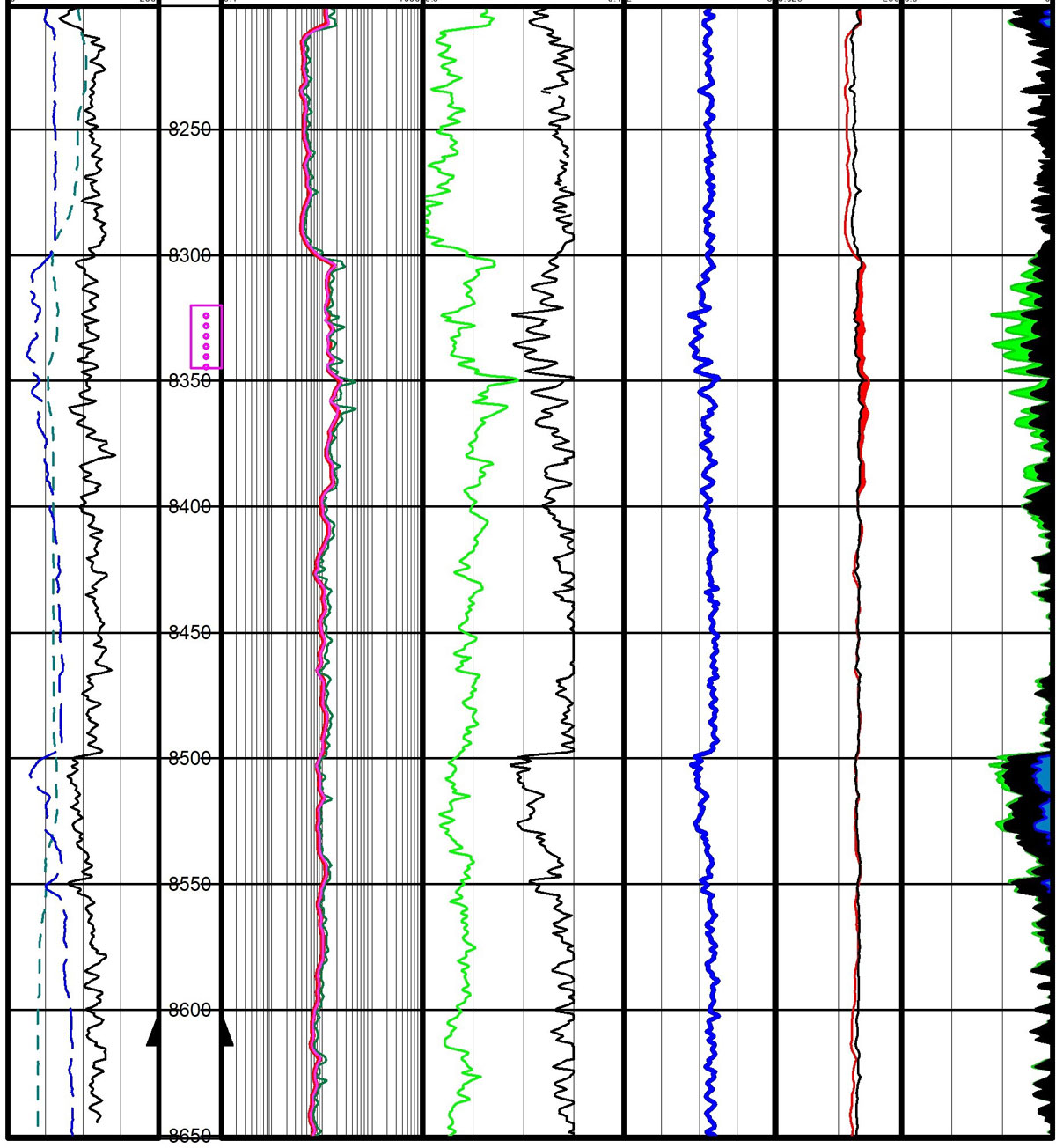
Conventional well in the Williston Basin that has produced 2.7 million barrels of oil. An Archie petrophysical model was applied, and the resulting ratios of oil (green), bound water (black), and free water (blue) are displayed in the far-right track. The productive and wet intervals are easily observable.
Full Petrophysics Skillset
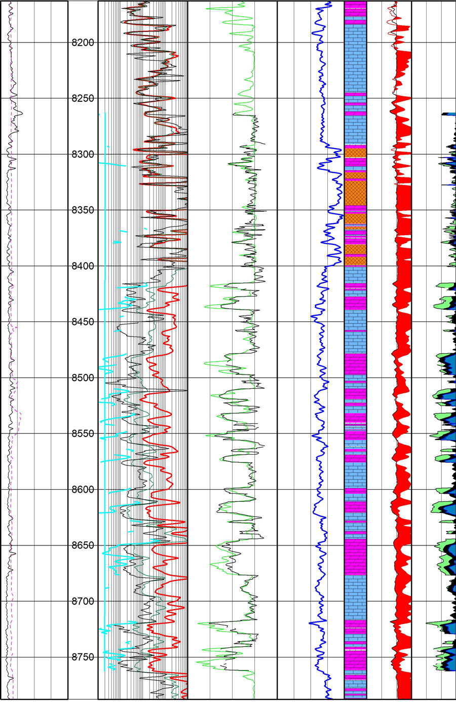
Well log display of a complex mix of dolomite, limestone, and anhydrite lithologies coupled with fluid calculations. Rock types derived from a log-log crossplot are displayed in Track #5 with lithologic symbols. Assigned density porosities and fluid fractions of oil (green) and water (blue) are displayed in the far right track. Rw and Rwa values (aqua) displayed in Track #2 validate input values. This display illustrates the upper dolomite section just below anhydrite beds to be highly prospective.
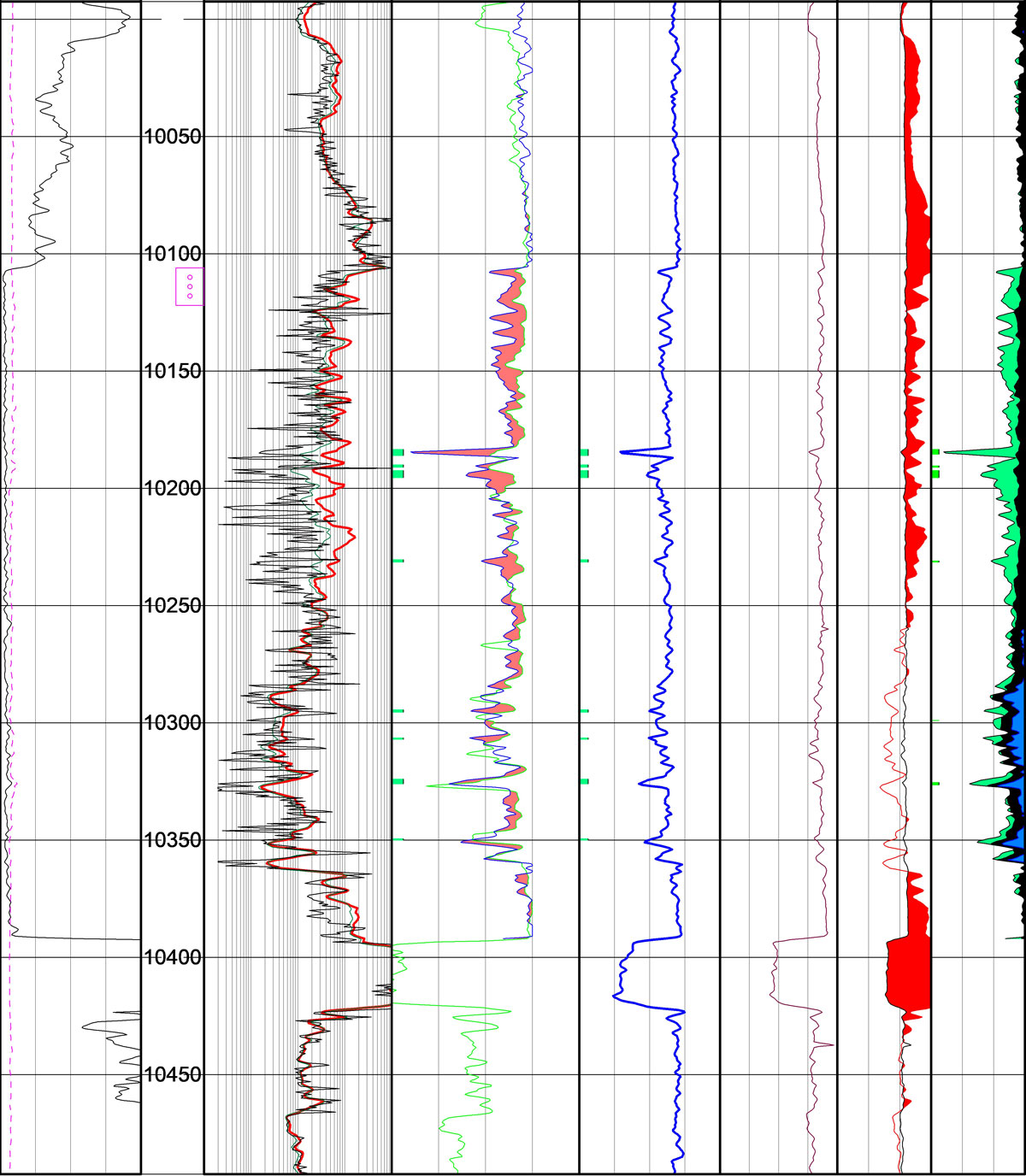
Well in the Powder River Basin that produces oil from a shaly sand. A Simandoux method was applied to accurately calculate the fluid ratios within this complex lithology. In the far right track, oil is represented by green, bound water by black, and free water by blue fill. Both a productive (upper) and wet (lower) interval are displayed.
Well Log Data Management
-
- Import and manage well logs datasets within interpretation software platforms.
- Source both public institutions and private companies. Utilize raster and digital datasets.
Integrated Pickett-Hingle-Buckles Crossplot Method
-
- This is an advanced and extremely powerful petrophysical application that provides the critical information needed for water saturation (Sw) calculations. Integration of all three log-log crossplots is crucial and helps accurately predict hydrocarbon and water ratios.
- Matrix density and DT values are derived from the Hingle Plot
- The Pickett Plot determines resistivity of formation water (Rw) as well as Archie exponents. (e.g. cementation exponent m)
- The Buckles Plot helps determine BVW irreducible values
- This is an advanced and extremely powerful petrophysical application that provides the critical information needed for water saturation (Sw) calculations. Integration of all three log-log crossplots is crucial and helps accurately predict hydrocarbon and water ratios.
Rw determination
-
- Leverage available produced water datasets from the USGS and state commissions.
- Calculate Rw from petrophysical methods such as Pickett Plots, Rwa calculations, or the SP deflection technique.
- Leverage available produced water datasets from the USGS and state commissions.
Lithologic determination
-
- Further understanding of matrix lithology through petrophysical applications of Hingle Plots and M* N* log-log crossplots. Accurate lithology determination provides accurate matrix density/velocity values and therefore accurate porosity values.
- Further understanding of matrix lithology through petrophysical applications of Hingle Plots and M* N* log-log crossplots. Accurate lithology determination provides accurate matrix density/velocity values and therefore accurate porosity values.
Transform Petrophysical Models
-
- Proprietary code efficiently and effectively applies petrophysical calculations to a multitude of wells. Porosity, Sw (Archie or Simandoux), Vshale, bulk volume water (BVW), Rwa, Ro, secondary porosity index, and various hydrocarbon flags can be quickly calculated for hundreds of wells in your study area.
- Proprietary code efficiently and effectively applies petrophysical calculations to a multitude of wells. Porosity, Sw (Archie or Simandoux), Vshale, bulk volume water (BVW), Rwa, Ro, secondary porosity index, and various hydrocarbon flags can be quickly calculated for hundreds of wells in your study area.
Volumetric Calculations
-
- Knowing the amount of hydrocarbons in place (OOIP or OGIP) in your field is extremely important for business decisions. Leverage the petrophysical techniques listed above to calculate original hydrocarbons in place within the appropriate fluid regime (oil, gas, condensate). Calculate present-day and ultimate recovery factors to help guide field development decisions.

Picket Plot diagram which is essentially a graphical representation of water saturation. Rw, m, and n values for Sw calculations can be extracted through this technique.
Contact
We look forward to working on your next project.
Moosetooth Geological Consulting, LLC
6547 S. Dexter Street
Centennial, CO 80121
(303) 501-2571
maurits.thayer@moosetoothgeo.com